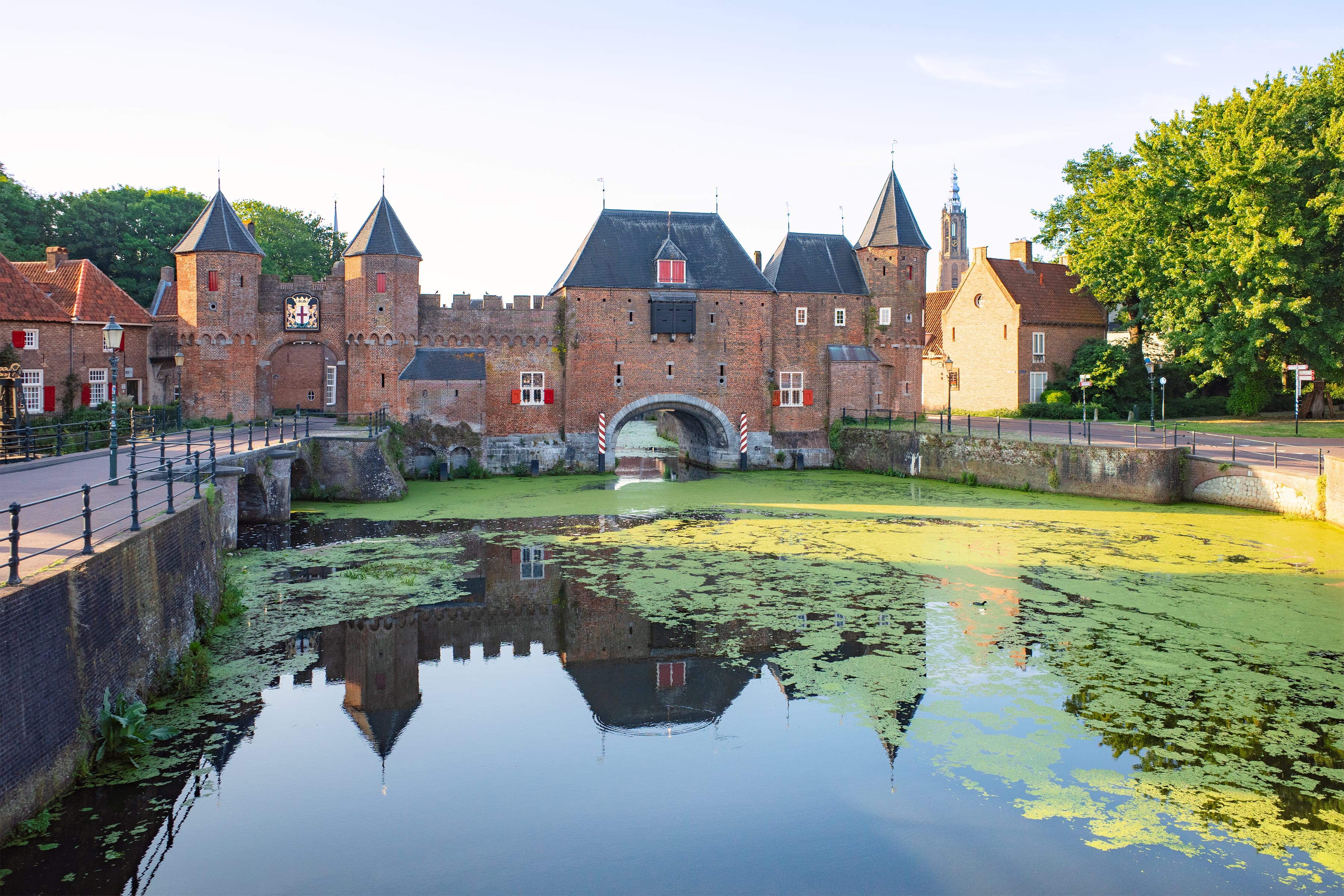
Utrecht city is a popular spot for day trips, both for tourists and locals. But have you ever explored — or at least heard anything — about the rest of the Utrecht province? Over just two days, Oksanka and I soaked in its beauty: from bright daylight to soft dusk, and even during the chilly Dutch summer night. Here’s how it was.

Since Utrecht borders South Holland, where we live, we decided to cycle there directly instead of taking a train to shorten the ride. The weather felt like an “aerogrill” — when a fresh breeze fools you into not noticing how you’re slowly roasting in the sun.
I pedaled fast through familiar territory, without stops. But when we were halfway through South Holland, I noticed something glinting in the sunlight: a cute, hare-shaped golden plate on a windmill. Naturally, the mill was called “De Haas” (“The Hare” in Dutch). Back in the day, many people were illiterate, and mills were often named after animals or plants to help workers tell them apart.

Our route was very green. We detoured around both Zoetermeer and Gouda — probably busy on such a warm weekend — and rode through the village of Sluipwijk, literally standing in the middle of a lake. Its streets were lined with houses, and beyond them, water stretched out in every direction. Suddenly, I saw a group of people gathered at an intersection. They were all enjoying ice cream from the “Opa Antonio” cart.

It turned out to be no ordinary cart: its owner, Antonio Rui, has been serving Italian ice cream in and around Gouda for 45 years! We picked our treats and sat down with the others on the canal bank.

As we left Sluipwijk behind, the land of Utrecht was right ahead.

At some point, we crossed into Utrecht, but the landscape didn’t change much.

Then something strange popped up by our bike path — a tilted, entirely black barn. We stopped to check it out. So, what was it? A 2022 artwork by Margreet Klaverdijk titled “Het Stormhuis.” The artist recently made a unique career shift from dental hygienist to full-time sculptor. Her artwork is a “folly” — a whimsical structure without practical function. It resembles a house worn down by storms, showing Klaverdijk’s exploration of how fragile human-built things are in nature.

Finally, we reached the first milestone of our adventure — Woerden!
Along with Gouda, this city is part of a well-known cheese-making region, full of shops offering unique local varieties, including some really aged cheeses — our favorite.

Only in Woerden did we realize how hungry we actually were! You know that odd sign of hidden hunger — when tiny things suddenly feel irritating. So, Oksanka and I hurried to find the nearest decent café.

After a late lunch with classic Dutch snacks and beer, we rode further around Woerden and stumbled upon a few ancient buildings. First up: Woerden’s town hall (1501–1538) with an old shame post on the corner. Oksanka for scale in the photo below.

In front of the town hall, we noticed a mysterious portrait of a woman mounted on the wall of a nearby house. I had a hunch it might be something historically interesting — and I was right! It was “Lady with Cigarette” (1911), the most famous work by Leo Gestel, a Dutch post-impressionist painter born in Woerden.

And how could we leave without seeing Woerden’s castle, built in 1407? Sadly, only the foundations of its thick corner towers remain, while the rest of it has undergone significant alterations since the Middle Ages. Interesting fact: In 1672, when the French invaded the Netherlands and destroyed many castles, they tried to blow up this one, too. But the people of Woerden stole the fuse before the French could ignite the gunpowder.

After Woerden, we rode toward Utrecht city through picturesque farmland, a patchwork of fields and groves.

Imagine our surprise when, in a shady part of the path, we were greeted by a group of friendly alpacas happily lounging on the grass behind a fence. They were so close and completely unbothered by us that we spent several minutes admiring them.

As we approached the village of Harmelen, farmland stretched out around us, dotted with farmers’ cozy home cafés and shops selling local fruit, vegetables, honey, and fresh milk. One large road sign, “KERSEN” (“Cherries” in Dutch), caught our attention, so we decided to stock up. Unsure what to buy without risking a mess on the ride, we settled on two bottles of cherry beer, a 2-kilo carton of cherries, and a cherry dessert sauce. We also grabbed a bag of enormous strawberries, but they were gone in an instant.

We were approaching Vleuten, once a village and now a neighborhood of Utrecht. Whenever I traveled to Utrecht by train, I’d always look out the window, hoping to catch a glimpse of the Hamtoren, the proud remnant of Den Ham Castle (1260). I’d wanted to see it up close one day, and on that day, we finally passed by!

Vleuten is much better known for Castle De Haar — the largest in the Netherlands — but I tend to avoid it. It’s a late 19th-century fantasy built on top of real medieval ruins. Of course, it looks fancy and attracts plenty of visitors, but it’s not quite my thing. Den Ham, on the other hand, is genuine. Although only its 34-meter-high keep remains today, you can still feel the spirit of history.

I did my best to get closer for a good photo, but the tower was tucked far behind a canal and a line of trees. Here’s the closest I could get — you can see the moat and the red brick reflection in the water.

I was so happy to finally capture the tower, but even more adventures were still waiting for us deeper in the Utrecht countryside.

We were probably already on the outskirts of Utrecht when we stumbled upon a replica of the city’s famous cathedral tower — in what felt like the most random place imaginable. It looked just like the one in “Madurodam,” the famous Dutch miniature park.

After finding the real story behind the replica, I realized that comparing it to the plastic exhibits at “Madurodam” was almost an insult. This tower was handcrafted by modelist Chris van der Sman using real 2-centimeter-long bricks. It weighs 7 tons and once stood in his garden. It took him 10 years and 40,000 bricks to create the tower! And the location wasn’t random at all: it was the city’s geographical center.

Then we turned away from the city center. Why? The thing is, we’ve been to Utrecht city many times and wanted to go somewhere a bit more off the beaten path. Our route went south along a beautiful canal.

As we left the dense residential area behind, a wide river, the Lek, came into view, and a sun-gilded bridge stretched across it. The sky near the horizon had already started to turn pink.

We crossed the river, and already from the bridge, we could see the towers of the town we were heading to — Vianen.

Like most small towns, Vianen was almost deserted before sunset. But despite its compact size, it was full of interesting spots. The first one we came across was a charming 17th-century water pump.

Then we rode onto the broad central street, which, as I understood, also served as the town square, with all the cafés and summer terraces clustered along it. The sun gently lit the windows of Lekpoort — a former fortified gate from the 1500s — at one end of the street and cast its light on the medieval brick cathedral at the other.

But the real pearl of Vianen is its Late Gothic–Renaissance town hall, built in 1425. The building has preserved its characteristic features to this day — most notably, its massive front façade made of so-called Namur stone (a blue limestone from quarries in what is now Belgium), topped with prominent battlements.

I was running around the town hall like crazy, unable to stop taking pictures of it in such perfect light!

The only thing that finally pulled me away from the town hall was my desire to also capture the Assumption Cathedral, a grand Gothic church founded in the 13th century. Its oldest part is the tower, while the rest of it burned down and was rebuilt under the patronage of Reinoud III, Lord of Brederode and Vianen — hence the building’s impressive size for such a compact town.

We were almost ready to leave Vianen when something across the canal caught my eye. Or rather, it wasn’t a canal at all — it was the former moat. And the buildings on the other side were built right on top of the remains of the fortified town wall! Look closely — see how the brick texture changes just above the ground-floor windows?

And here is the rounded base of the former defensive tower.

It was time to head back to Utrecht. We crossed the bridge over the Lek again, and both the sky and the water were such a deep, vivid blue that I could hardly believe it was natural.

We knew we were back in Utrecht as soon as the high-rises appeared on the horizon. The city was slowly lighting up, but it was already too late to explore. Summer nights in the Netherlands can be deceiving — it still looked like twilight outside, but the clock was already nearing midnight. This ride was meant as a day trip, and we hadn’t planned to stay overnight (at least not on this particular day).

So, we reached the railway station, which felt like the brightest spot in the entire city. Our train was just 10 minutes away.

Back home, I was happy to find that the carton of cherries had survived the ride with barely a bruise, and the glass bottles were still perfectly intact. Oksanka and I didn’t deny ourselves the pleasure of eating half the box of cherries before bed, without worrying about a tummy ache: we wouldn’t have noticed anyway — so sleepy we were.

One day trip to Utrecht wasn’t enough, so we decided to return a week later, starting exactly where and when we left off. We took a Friday evening train with our bike and a slightly crazy plan: to ride through the province overnight and reach its far side by morning.

I showed you the replica of St. Martin’s Cathedral, which we found during the first day trip — now it’s time to admire the real one, glowing in the evening light.

Construction of Utrecht Cathedral began in 1254 and continued, in one form or another, until the 16th century. It was once the largest church in the Netherlands, but a 1674 storm destroyed the nave — and it was never rebuilt. That’s why the tower now stands apart from the rest of the church, with a square in between.

Utrecht is a bustling city full of shops, restaurants, and museums, but we came looking for something a bit more niche. So, fast forward from the Middle Ages to the 20th century, and let me present to you the Rietveld Schröder House (1923–1924) located on the city’s far western edge in a calm residential neighborhood.

Here’s why this house is so peculiar. Dutch architects Truus Schröder-Schräder and Gerrit Rietveld designed more than just a city home — it was a manifesto rejecting traditional design rules. They used primary colors, geometric forms, and overlapping surfaces. As part of the De Stijl movement, the architects aimed to reshape art and design in response to the sweeping technological, scientific, and social changes of their era.

The house stood near the edge of the city, and from there, the only way forward for us was to leave Utrecht behind.
Next, we cycled to Houten, a town southeast of Utrecht that’s often praised as one of the best-designed modern municipalities in the country.

Its standout feature is a row of colorful townhouses by the lake, connected by a bike path that runs right over the water.

And after Houten, we dove into the night forest.
Yes, a forest.
The Netherlands is one of the least forested countries in Europe, so stumbling upon a large, dense thicket feels almost surreal, especially at night. East of Houten lies the Utrechtse Heuvelrug National Park, which is full of bumpy trails perfect for mountain biking, with roots poking through the ground, sudden ups and downs, and sneaky sand pockets.

As you might remember, we weren’t on a mountain bike. So, Oksanka and I switched on the extra-strong lights mounted on our helmets and rolled through the trails at a cautious pace. The forest around us felt thick with moisture; insects were tapping against our helmets like rain on glass. In the beams of light, tiny drifting particles hovered above the moss, as if the forest was quietly exhaling.

The trail ended in about an hour, and we switched to a more regular dirt road that led us to one of the Netherlands’ most unexpected landmarks — the Pyramid of Austerlitz (1804). It’s a 33-meter-tall grass-covered pyramid with a stone obelisk on top, built in just 27 days by Napoleonic soldiers stationed nearby. Their general, Auguste de Marmont, wanted to keep the troops busy and was inspired by the pyramids he’d seen in Egypt. The monument was initially called “Mont Marmont,” but it got renamed after Napoleon’s big victory in the Battle of Austerlitz.

Taking a decent picture of the pyramid was a challenge: it took me half an hour to position the camera just right and light up the structure using the strongest setting on my helmet lamp. I took a couple of dozen pictures, but the one above was the best.
I don’t quite remember what was going through my head, but after the pyramid, we were speeding through the forest to the east, toward the geographical center of the Netherlands. Ironically, it’s not in Utrecht Province, but just over the border in the neighboring one. Since Utrecht is the most central province anyway, it felt right to stop by the exact center, even if it technically belongs to another province.

The geographical center, marked by a large stone, sits on Goudsberg Hill near the village of Lunteren. It’s right on the edge of the Veluwe — an even bigger forest than the one near Utrecht. But we’d had enough of forest trails for the day. So, we rested near the stone for a few minutes, ate our sandwiches, and then turned northwest toward a city with remarkably preserved medieval heritage — one that would make our adventure unforgettable.

It turned out to be extremely cold and humid. Oksanka threw on another jacket — she was freezing on the rear seat — while I tried to warm up by pedaling harder. I usually dress a layer or two lighter on cycling trips, but even with two T-shirts, I could feel the chilly breath of dew from the fields.

And then we reached it — Amersfoort.
Its old center still feels like stepping back into the Middle Ages. From the iconic church tower and fortified gates to narrow streets and canals — so many of the original structures are still standing.

Amersfoort got its name from an old crossing point over the river Amer (now called the Eem). That shallow spot made it a natural place for traders to pass through, and that’s where the city began. In the past, Amersfoort was buzzing with life, famous for its textile trade and breweries.
Fun fact: Amersfoort left its mark across the ocean! In the 1600s, Dutch settlers in America named one of their towns “Nieuw Amersfoort.” It was located in what is today Brooklyn, New York. And just in case you didn’t know, New York itself was founded by the Dutch and originally called “New Amsterdam.”

6 a.m. The city was asleep. The only sign of life was on the main square, where a few people were installing tents and unloading goods from trucks for the Saturday fair. Everywhere else, the streets were silent. We parked the bike and wandered on foot, charmed by the little old houses, quiet canals, and the birds singing.

Just like in Utrecht, Amersfoort’s main landmark is a standalone Gothic cathedral tower (1444–1470), while the church it belonged to is long gone. After the Reformation, the church was used for all sorts of things — at one point, even as a gunpowder storage and grenade lab. In 1787, a tragic accident happened: the church exploded due to a mishap in the lab, killing seventeen people. The ruins stood for a while, but were finally torn down.
On that morning, the tower looked fantastic: red brick contrasted with the shade of trees and was gilded by the sun.

Amersfoort had so many atmospheric corners and beautiful old buildings that I kept wandering around with my mouth open, constantly stopping to take photos. Just next to the tower stood the charming “Kapelhuis” (Chapel House), dating back to around 1500. The house leans forward slightly and looks a bit like a gingerbread hut from a fairy tale.

As we wandered through Amersfoort’s old town, one building really stood out — Groot Tinnenburg. It’s the biggest and most famous of the so-called “wall houses” (“muurhuizen” in Dutch), built right into the city’s first defensive wall around 1300. Originally plain and fortress-like, the Groot Tinnenburg later became a stately mansion with big windows and a garden.

In the photo above, you can see the traces of the original water gate. As Amersfoort grew, parts of that first wall were taken down for bricks and built up with houses, while a second defensive wall went up farther out. If you follow the canal just about five minutes from here, you’ll come across the Monnikendam Gate, which provided passage to the city through the second defense wall.
I had an impression that the vault was really low, so I wonder if only small boats could pass through, or if maybe the water level was different back then, giving more clearance.

But I was keeping Amersfoort’s most notable site for the dessert.
When it comes to medieval gates, the undispited champion is actually on the opposite end of the old town. It might not be the tallest, but in my opinion, it’s the most impressive one in the whole country.
Ta-da—please welcome the Koppelpoort!

The Koppelpoort (1380–1425) is a rare example of a double gate that served both land and water traffic. The old Dutch word “koppel” referred to the common grazing land outside the city, hence the name.
The Koppelpoort was never breached. For example, during a siege in 1427, the Duke of Burgundy tried to invade Amersfoort amid a local power struggle. His army attacked the gate, but the town held its ground. According to historical records (or legends?), local women also joined the defense, pouring boiling beer on the attackers from above!

Every morning and evening, the massive gate was raised and lowered by a group of at least twelve so-called “raddraaiers” (“wheel-turners”), gathered by guards. It was a risky job: if anyone didn’t move in sync and fell, he or she would drag the rest, often with deadly consequences. While lowering the gate, wheel-turners first had to slightly raise it to remove the locking pins, and as the gate descended, the wheel picked up speed, frequently causing a few broken bones.

It’s hard to describe, but the Koppelpoort felt both massive and small at the same time. Compared to castles in France or Germany, medieval fortifications in the Netherlands are usually modest, but when you come close, you realize they are still towering over you.

By 7 a.m., the city was slowly waking up, with early risers heading out for fresh bread. We found a cozy bakery nearby and stopped for a coffee and a fresh apple cake. Not the usual kind with apple bits on a dough base — this one was a fluffy sponge, soaked with apple syrup. That cake became our last bright memory of the trip; we were happy but sleepy and unable to enjoy anything else. I turned on my inner autopilot mode and brought us to the station.
Leave a Reply