Spring has finally arrived! Not that March teaser that lasted precisely one day, but a true spring with buzzing bees and countless lambs, calves, and foals gambolling in the fields. Oksanka and I picked the first free weekend to explore the northern part of the Dutch Hanseatic route, which once united the greatest medieval trade centers along the IJssel River.

Our journey started in Deventer, one of the country’s oldest cities. It boasts the oldest stone house, the oldest public park, and the oldest scientific library in the Netherlands!

Naturally, our first stop was the oldest house in the country, known as the Proosdij. Its core dates back to around 1130 — older than the cornerstone of Notre-Dame de Paris! While we often see medieval churches or town halls, it is rare for a regular house to survive so long. In the past, only creations intended for God or the State were built for eternity, while common houses were much more fragile.

The Proosdij was named after its founder, Provost Philip of Katzenelnbogen, and served as his residence and the administrative heart of nearby St. Lebuinus Church. The house was made of volcanic stone imported from the Eifel region in modern-day Germany, since local soil only provided good clay for bricks.

Deventer charmed us with its narrow, curving streets, now lush with greenery thriving in the spring warmth.

In one of those narrow streets, I noticed something peculiar: a pair of “luchtbogen” (meaning “air arches” in Dutch). Since river cities like Deventer were built on soft, unstable ground, tall medieval buildings had a tendency to lean over time. If two houses across an alley began tilting toward each other, an arch was built in-between to lock them in place. In dense quarters, these arches also acted as “fire-stops.” If a house caught fire and collapsed, the arch prevented the neighboring walls from falling with it, saving an entire block.

Next, we headed to the Waag (weighing house), which overlooked the buzzing square with the Saturday market. Most Dutch towns have a weighing house that is a few centuries old, but Deventer’s Waag is the oldest and arguably the most exquisite. It was built between 1528 and 1531 in a Late Gothic style and nowadays has a noticeable lean — its western facade is a full 80 centimeters out of plumb!

I walked around the building, scanning the walls for a specific object I’d read about. Ah, there it was — a copper cauldron hanging on the facade. Deventer was part of the Hanseatic League along with dozens of other wealthy merchant cities, and it took honest trade so seriously that anyone caught forging coins was boiled alive in oil. If people couldn’t trust the coins in their pockets, the whole economy would collapse.

The most famous person boiled in the cauldron was the local mint master himself. In 1434, a special cauldron for his execution was smithed. This cauldron stayed on the wall for centuries as a warning to anyone thinking of cheating the system.

Before heading out, Oksanka suggested a quick stop at the market for supplies. After that, our route took us past rows of brick merchant houses with typical stepped gables. Many facades displayed their construction years, some dating back as far as the early 1600s.

We rode along the river to a much less ancient site: the IJssel Line. This was the Dutch portion of the NATO Cold War defense between 1951 and 1964.

It consisted of anti-aircraft positions, command and hospital bunkers, and embedded tank turrets, all designed to protect Western Europe against a potential Soviet invasion.

But the most peculiar part of the IJssel Line was a system of mobile dams and locks. Once activated, they would force the river over its banks, turning the valley into an impassable swamp in just a few hours and halting any advancing force.

The line was kept strictly secret; even the local population didn’t fully know the scale of the bunkers being built in their backyards.

Had an invasion triggered the plan, the entire 127-kilometer IJssel valley would have been swallowed by water, displacing 300–400 thousand people and destroying the region’s agriculture.

Walking past the bunkers, we found them in perfect condition even after several decades. They sat in such a peaceful area, covered in grass and flowers, making it even harder to imagine the catastrophic sacrifice that was planned for this landscape. But given that our home country, Ukraine, had the misfortune of experiencing both Nazi and Soviet terror, I suspect that sacrifice might have been the lesser evil compared to joining the “prison of nations.”

We rode past an air defense turret, where a beautiful horse was grazing on a perfectly green field. We were just about to leave when the owner came to pick her up. He mentioned she was 34 years old!

After the heavy history of the IJssel Line, we rode further, passing numerous farms with cows, sheep, and horses. Many animals were accompanied by their newborns, who jumped around while their parents preferred to rest in the shade of the trees.

This stretch seemed completely flat when I was planning the route, but we found a few gems along the way. I couldn’t help but stop when I saw the surreal sculpture “Ga’k, Ga’k nie!” (meaning “I’m going, I’m not going!” in the local dialect). It was made in 2007 by Albert Dedden and Paul Keizer and looks expectant and curious, leaning forward as if it’s about to move, yet there’s a slight hesitation in its stance.

Just down the road, we found another piece by the same creative duo. Titled “Neerslager” (2005), it refers to the workers who once fueled the local brick industry. You can see the figure’s motion as he strikes a clay-filled mold onto the ground; this allowed the bricks to dry before they were sent to a kiln (industrial oven) for hardening.

The sculpture was the perfect introduction to our next stop: the ruins of the “Fortmond” brick factory on the banks of the IJssel. The local soil was once ideal for production, yet few remnants of this thriving industry have survived to the present day.

This factory operated between 1889 and 1976. At its peak, it produced roughly 14 million bricks annually with a team of only 25 workers. After it shut down, most of the buildings were either demolished or left to decay, allowing the area to be reclaimed by nature.

I looked inside one of the kilns. Unlike older kilns that had to be cooled and emptied after every batch, the ring kiln never “slept.” The fire moved continuously from one chamber to the next through narrow openings: while one was being fired, another was cooling, and a third was being loaded with freshly dried molds.

We climbed the observation tower to look out over the river and the Duursche Waarden Nature Reserve, where fresh greenery was slowly hiding the scars of past industry.

From above, I spotted a small boat behind the trees. It turned out to be the local pedestrian and bicycle ferry. Records show a ferry has operated at this spot as early as 1379, and during the peak of the brick industry, it was a vital link for the factory workers.

We didn’t need a crossing that day, so we rode straight through the nature reserve instead. It looked wild and overgrown, as if it had never seen any human activity (if you ignore the bike path, of course).

Fallen trees and branches lined both sides of the path, likely brought down by the winds that sweep across this completely flat area.

The spring was in full bloom, and we could smell blossoms everywhere. However, heavy rain clouds were starting to look threatening, so we had to deviate from our plan to explore Zwolle. Oksanka had been monitoring the forecast and calculated that we could beat the rain if we only have a dinner in Zwolle and then go straight to our B&B in Kampen.

The irony? We didn’t make it to Kampen dry. Despite all the minute-by-minute weather analysis, we were caught in the heaviest part of the rain in the open. We were soaked to the skin, except for the parts protected by our rainproof jackets; even the change of clothes in our bags got damp. So, instead of walking around Kampen, we spent the evening drying our things and went to sleep super early.
But there is no bad luck without a silver lining. I got up before sunrise and headed out to photograph the empty streets of Kampen. Oksanka knew about my plan but preferred to keep sleeping rather than suffer through the wait at every spot while I obsessed over the composition.

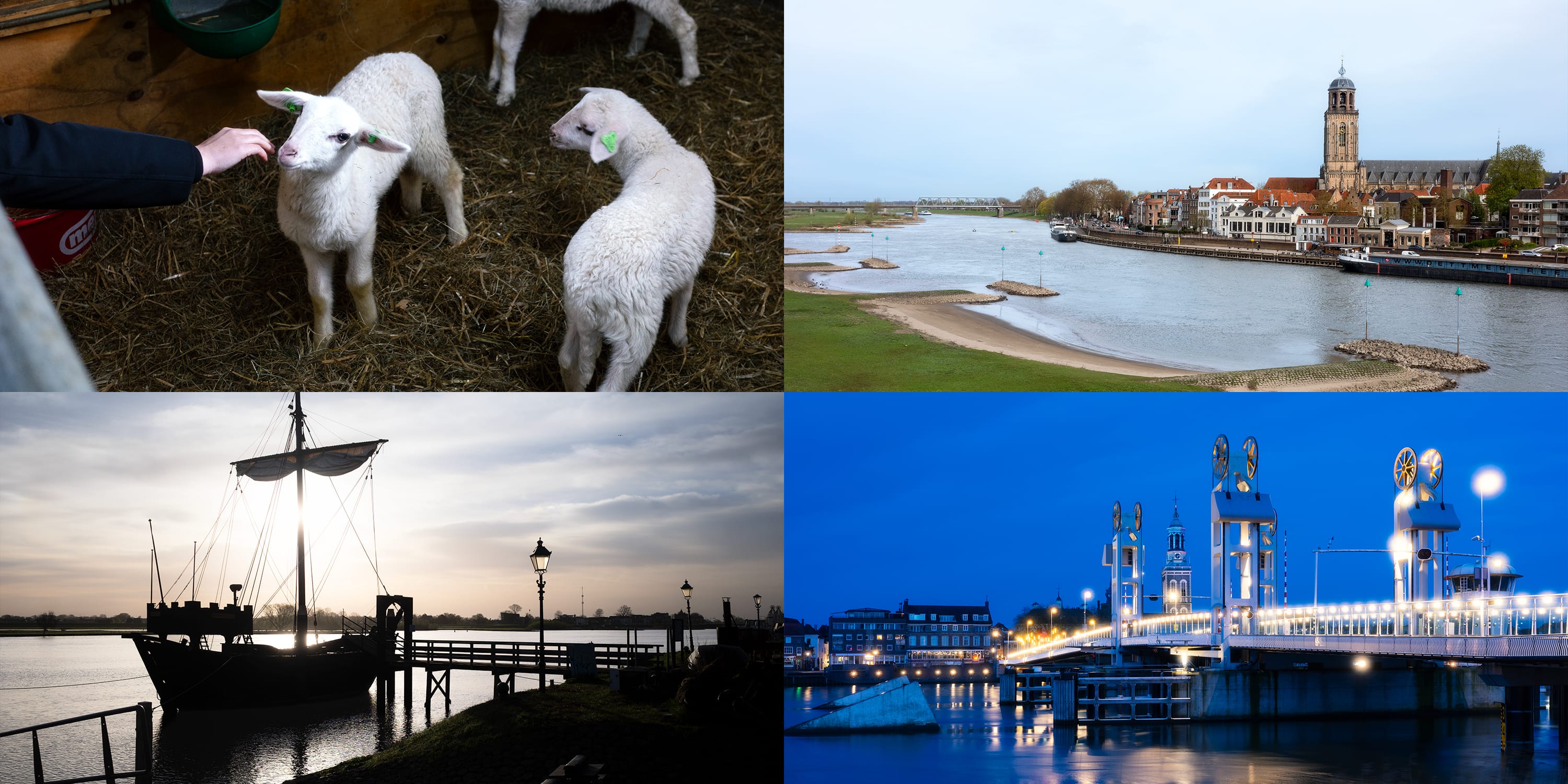
I crossed the IJssel to capture the city panorama. At that early hour, everything was bathed in ultramarine, and the city lights were still glowing. Dominating the skyline was the spire of St. Nicholas Church, better known as the Bovenkerk. It was built in the 13th century in the Gothic style and completed two centuries later. It serves as the final resting place for many prominent Kampen’s citizens.

Then I turned my gaze back toward the bridge I had just crossed. It’s relatively new, dating only to 1999, though a city bridge has spanned the IJssel since the Middle Ages. Between the bridge’s columns, I framed the Nieuwe Toren (New Tower). This freestanding structure was commissioned by the city government and completed in 1663 to showcase Kampen’s status as a wealthy Hanseatic city during the Dutch Golden Age. It served no religious purpose, though at first, I found myself looking for the church it should have been attached to.

I moved on to the old city defenses. Just as the streetlights flickered off, the first rays of sun caught the window glass. I reached the Broederpoort, one of the three gates still standing today. The gate was moved here in 1465, and you can see it in the architecture — a mix of pointed Late Gothic towers and decorative Renaissance details. Its name comes from the “brothers” of the monastery on the same street.

I moved on to the Cellebroederspoort, the second gate named after another local monastery. Since it was built in the same period, the two looked quite similar, so I spent my time capturing the beauty of the surrounding park.

I didn’t know the city yet, and it felt like I was wandering aimlessly, stopping whenever something caught my eye. One of such details was a dolphin-shaped handle on a door.

Meanwhile, the sun finally peeked above the horizon, emerging from under a cloud. The city was slowly waking up, and a few dog owners appeared for their morning stroll. I didn’t expect it, but I bumped into our B&B host; he looked a bit surprised to see me out so early.

Finally, I reached the third city gate — my favorite of them all. Facing the river, it looked the most massive and truly “medieval.” The central section of the Koornmarktspoort (meaning “Grain Market Gate”) is from the 14th century, while the towers were added later.

The sun gently lit the surroundings. It was calm and dry, as if there had been no rain at night, and I still hadn’t explored the other half of the old town!

I rode to the Oude Buitenhaven (Old Outer Harbor). While the city once had several harbors, only this one still felt historical.

The harbor featured several reconstructed buildings designed to feel like a 14th-century shipyard. In contrast to the wealthy brick manors in the center, the harbor was a place of labor and thus far less posh. Everything here was functional, built for work rather than show.

Architecture aside, the real highlight was the Kamper Kogge. It is a meticulous reconstruction of a 14th-century merchant vessel known as a cog. During the city’s golden age, these waters were filled with them. Captains would drop anchor here to wait for the right wind or to settle various trade tolls required by the Hanseatic League. This was the “workhorse” of the era, capable of carrying 60 tons of cargo.

In the Middle Ages, a cog was built in four months because Hanseatic shipyards worked as highly efficient “assembly lines,” but the modern reconstruction of the Kamper Kogge took four years (1994–1998).

I noticed an elevated platform at the back of the cog — like a mini castle. Since merchant ships were frequent targets for pirates, this platform allowed archers to fire down onto attackers.

I was lucky to see the cog at the dock as it’s often away on tours around the Netherlands or to nearby countries like Germany or Denmark. One day, Oksanka and I hope to see it under full sail, heading out to sea.

Speaking of Oksanka, she had woken up and was trying to call me. While I was absorbed in exploring the city, she worried I’d be late for breakfast and leave all the packing to her. But my timing was perfect; I had everything under control and was on my way back.
As we prepared to head out, the sun climbed higher and the air turned warm. I showed Oksanka all the best spots, feeling proud of my new knowledge of the area.

The streets were still fairly empty, but not because people were still sleeping — the Sunday church services hadn’t ended yet.

I found several “luchtbogen” spanning the narrow alleys, much like the ones we had seen in Deventer. I suggested that Oksanka walk through one of them to feel the curvature of the old brick walls.

But then it was truly time to head out of Kampen toward Zwolle, which we hadn’t had a chance to explore because of the rain.

Our route took us through tranquil fields and pastures; once again, we found ourselves adoring the animals, especially the lambs and the ponies.

I slightly detoured to the Vreugderijkerwaard Nature Reserve in the IJssel floodplains. Its main feature is a long channel running parallel to the river. This channel acts as a safety valve, letting water pass through during floods to protect Zwolle, all while creating a beautiful, thriving home for local wildlife.

What we definitely didn’t expect was to come across Hereford cattle. These cows and bulls have a peculiar way of looking at you from under their brows, almost as if they’re ready to charge — though they are actually very calm and friendly. They live outside year-round, serving as “ecological mowers.” Their grazing keeps the area from turning into a thicket, which is vital for local birds and rare plant species.

From the open pastures, the road led us straight to the heart of Zwolle. We entered through the towering Sassenpoort, the city’s last surviving medieval gate and one of the most iconic fortifications in the Netherlands. The gate was built in the late 14th and features a machicoulis — an extension between the towers with holes used to pour boiling pitch over invading enemies.

According to legend, even the ruthless warlord Maarten van Rossum couldn’t outsmart the Sassenpoort. He supposedly attempted to sneak his troops past the guards inside a hay wagon. But the suspicious guards waited until the wagon entered, then dropped the gates — trapping the invaders in the narrow space between the outer and inner doors.
While we had known about the medieval gate before, neither Oksanka nor I had ever heard of the next place. As we rode along the street, a weird blue egg emerged above the houses. It was the color of the sky, but had a different, rugged texture.

We approached, wondering what it was, and it turned out to be a contemporary extension of the 19th-century museum building. The structure was designed by architect Hubert-Jan Henket and is officially called “De Wolk” (“The Cloud”). It owes its unique texture to 55,000 handmade ceramic tiles produced by Royal Tichelaar, the oldest ceramic company in the Netherlands.

The weather was mostly sunny, but we were checking the forecast and the cloud color all the time, not quite trusting the warmth — our skin still remembered yesterday’s shiver.

Like most Dutch cities, Zwolle demolished almost all of its old fortifications to allow for modern expansion, but a few sections remained. The scale impressed us both. If this small fragment was already so tall and thick, the original circle of walls must have been enormous.

We found some great coffee in Zwolle and, fueled by the caffeine, continued our ride eastward. The route took us along the Almelo Canal on a narrow path lined with vibrant, richly decorated boathouses and residential barges. It felt as if we were passing through a community with its own distinct subculture.

After leaving Zwolle, the landscape was plain for several kilometers until we reached the village of Dalfsen. There, perched on a small hill, I noticed the “Floating Boulder,” a 2000 artwork by Dutch artist Bas Maters. The sculpture features a 23-ton natural stone that appears to float effortlessly, but it actually stands on an ingenious hidden support system.

The boulder was a surprise, but our true destination was Rechteren Castle, the only medieval stronghold in Overijssel Province continuously inhabited by the same family and that has never been a ruin.

While most estates in the region were modernized until their medieval origins disappeared, Rechteren kept its core: a massive 14th-century round tower. This tower was designed to be the final sanctuary for those inside if the rest of the castle fell to the enemy.

The castle is private and not open to the public, so we enjoyed it from a distance. To be honest, it was only the tower that truly captured my interest; I’d like to see its ancient stone up close one day, while leaving the comfort of the interiors to those who call it home.

Meanwhile, we rode further east toward Ommen. I noticed something curious by the roadside and we stopped to investigate. A small, fenced-in hill turned out to be a man-made foundation for a stronghold. In the 12th and 13th centuries, local lords built these “motte” castles to defend their territory. What an unexpected footprint of the Middle Ages!

We were close to our final stop when Oksanka’s intuition kicked in. She pointed toward something and said firmly, “We need to go there,” so naturally, I looked for a place to park the bike. Like most Dutch cities, Ommen had a petting zoo, but this one housed “lammetjes” — cute baby lambs born this spring! We had spent the day watching them from afar in the pastures, but here, Oksanka finally got her wish to pet them. One of them even gave her a gentle, curious bite.

Afterward, we went to see the other residents: sheep, goats, emus, doves, pigs, and rabbits. A peacock jumped onto the fence right in front of me; perhaps he saw the camera in my hand and decided it was time to pose. Oh, what a narcissist of a bird!

We almost forgot our original destination, but I checked the time and suggested we wrap up with the animals. Filled with positive emotions, we finally reached the Sahara — a 20-hectare sand drift hidden within the Ommen forest.

Although forest dunes are not alien to the Netherlands, this particular area was created through human activity. Overgrazing by sheep and the harvesting of peat decimated the original heathlands. To keep the drifting sand from swallowing the surrounding farms, 19th-century foresters planted a dense perimeter of pines. Today, those trees act as a living border, holding the mini-desert in place.

I was surprised by the crowd at the Sahara. There were people scattered across the dunes, but the sheer expanse of the sand swallowed the noise and the movement. We didn’t plan to relax on the warm sand for long; after a quick pause, we set a course toward Deventer, where we would catch our train home.

It was only us and the forest. The sun gently highlighted the fresh green leaves and threw long shadows onto the road. It was a beautiful moment, but we kept our pace mindful of the several dozen kilometers ahead of us.

As I checked the battery charge, I happened to notice that we had just crossed a 10,000-kilometer milestone on our bike! Not bad for the two years we’ve spent cycling together in this setup, discovering the Netherlands.

We finally pulled into Deventer, battling a headwind that intensified with every kilometer. I navigated one last loop through the old center to capture a final memory of the trip: the Kranensteeg. This narrow alley, bridged by a series of “air arches,” has become our personal symbol for the Hanseatic cities along the IJssel. Not the towers or mansions, but these humble elements that held the fabric of a prosperous city together.

Leave a Reply