Lelystad to Urk: the “Observatorium,” shipwrecks, and polder syndrome
Oksanka and I first stepped onto Flevoland soil by pure chance, while returning from a summer adventure in North Holland. The two provinces are linked by a 26-kilometer dam, the Houtribdijk. We crossed it to catch a train home and to get a glimpse of this famous structure, since we happened to be nearby anyway.

The Houtribdijk was the most humid place we’d ridden. We thought we were used to the Dutch climate, but on this dam, the air felt like a jungle. My hands got covered with droplets of moisture, which didn’t dry in the headwind!

Since it was the end of a long ride, we didn’t have the energy to explore even a fraction of Flevoland. We arrived at the station just in time for a direct train and then forgot about the region for a while.
Several months had passed, and honestly, Flevoland stayed low on our list of places to visit. But one winter day, I set off for a solo ride in the east of the country, only to realize at the station that trains were temporarily down. With no other choice, I took the available direction toward Lelystad, the capital of Flevoland.

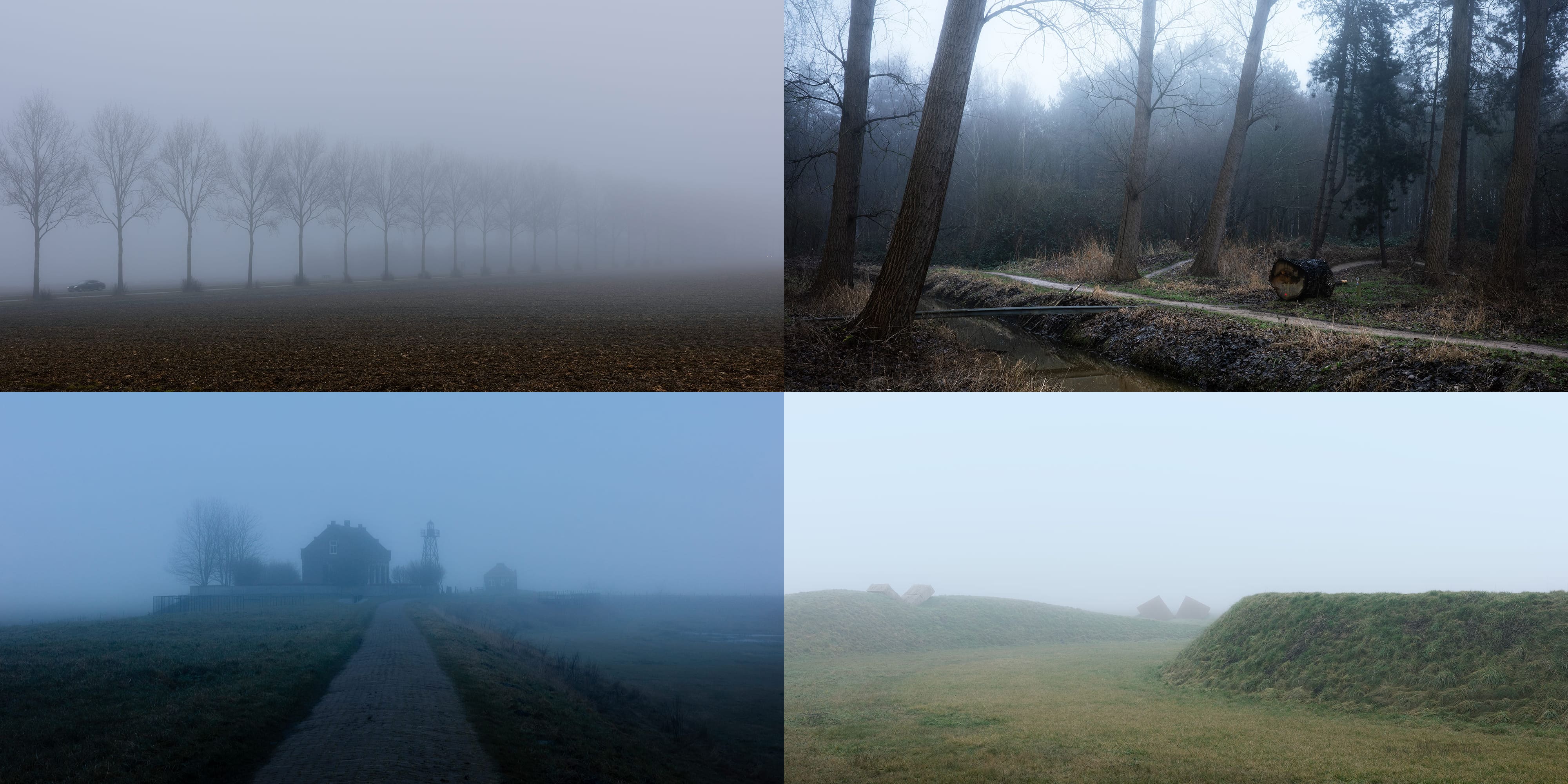
The day started sunny. At least, it was when I boarded the train, but halfway there, all the light vanished. A thick fog swallowed the landscape, and my worry of sweating in too many layers had gone.

I quickly passed through Lelystad and rode north. Although Flevoland is likely the flattest part of the country — a place where you can usually see for kilometers in every direction — the fog hid the horizon entirely.

There is a sterile perfection to Flevoland. It’s almost entirely reclaimed land, drained in several stages between the 1940s and 1970s. The landscape looked flat and geometric, and I felt like riding across a blueprint.

As a newly inhabited area, Flevoland cannot boast many historical landmarks; however, it is populated with modern open-air artworks — there is simply plenty of space for them. And I happened to stumble upon the first Land Art project in the region — “Observatorium.” It was created by American artist Robert Morris in 1971.

“Observatorium” consists of two circular earth walls with V-span stone visors. Through the central visor, one can see the sun rise at the beginning of spring and autumn, when day and night are of equal length. Of course, on this winter day, there was no sun — only a milky void all around.

Like many artists in the 1970s, Morris was fascinated by prehistoric monuments, and this trend reached beyond the art world. Around that time, Stonehenge, for instance, had become a site of pilgrimage for those seeking a connection to the ancient and mysterious. Standing there in the fog, I could absolutely feel that lineage.

As I rode toward my next stop, I noticed the peculiar farmsteads. Unlike other provinces, where centuries-old farms are built from brick, wood, and thatch, Flevoland’s barns are made of “vibrated concrete” panels. Vibrating the concrete during the curing process forces air bubbles out to create a smooth finish. These panels were mass-produced in the 1940s and 1950s to settle the empty land quickly; after World War II, such efficient, low-cost production methods were essential.

The landscape was peak minimalism. Most of the time it was just soil and fog, without a single tree in sight.

A few times, I spotted unusual orange ship signs in the middle of nowhere. From a distance, they looked like road signs, but as I drew closer, it was clear they were something else. It remained a mystery until I looked them up: these markers identify sites where shipwrecks were discovered, some dating back to the Middle Ages.

I started to drift into “polder syndrome,” where the mind stops paying attention because there is nothing but empty, straight lines. Fortunately, before the monotony took over, I approached the Ketel Bridge, which links the two halves of Flevoland.

Urk: the fishing island that refused to become mainland
It wasn’t long before I reached Urk, probably the most peculiar corner of the region, if not the entire country. Locals warned me it was a place of “oddities.” People here speak a dialect that sounds like a different language, maintain a deep religious devotion, and defend their independence with an almost fanatical ferocity.

Urk was an isolated island community until 1942, when the reclamation project tethered it to the mainland. Despite this, it still feels like an island; locals will tell you that you are on Urk, never in Urk. It has one of the lowest migration rates in the country. The town even has its own national anthem. Nearly every resident belongs to a religious denomination and attends church. I had been there for only ten minutes when a man approached me on the street to hand over a religious brochure!

The first things I saw upon entering the town were the fishing vessels of different sizes and types. Dozens of them — and they looked damn operational, not just there for decoration.

The harbor was massive for such a compact settlement. Back when Urk was an island, the fishing infrastructure alone occupied half of the old center. I hadn’t looked at a map of Urk beforehand, preferring to let the exploration unfold naturally.

Urk offered a stark contrast to the rest of the Flevoland region. Its layout was dense and chaotic; because the island had such limited space, houses were built without any formal street plan.

All the cafes and shops were closed, and at first, I didn’t realize why. I hadn’t known that locals observe Sunday with such strict religious devotion; for many here, even riding a bike is considered unacceptable on the Lord’s Day — I was the only person on a bicycle in the entire town.

With my bright red bike and matching helmet, I felt almost like an intruder, drawing stares from the few locals who were out. Yet, it was worth it to experience Urk in such an intimate state.

As I wandered, I came across a curious relic — a tanning oven for fishing nets and sails. In the past, when gear was made entirely of natural fibers, fishermen had to regularly boil it in a solution of wood extracts to prevent rot. The oven even featured a crane, designed to hoist the heavy, saltwater-soaked nets from the tank.

The people of Urk were once the fiercest opponents of the land reclamation project, fearing it would swallow their identity and “kill the island.” Yet, the very thing they resisted became their greatest asset. Highways and extra space helped transform an isolated community into the province’s economic engine — not just through fishing, but also processing imported seafood.

After the harbor, I headed toward the Urk lighthouse. It began in 1617 as a simple coal fire, serving both the local fleet and ships navigating from Amsterdam to the North Sea. The current tower is much newer and dates back to 1845.

Since I visited in a thick fog, I wondered how far could the light reach in such weather. From just several dozen meters away, the lighthouse’s silhouette was already bleached out.

Before leaving Urk, I stopped at one more spot, the Little Church by the Sea. It was built in 1786 on the foundation of an even older one. Curiously, they don’t hold regular Sunday services here anymore, though people still get married in it, and in the winter, you can catch special services held in the local dialect. The oldest piece of the building is the tower bell, which has been ringing since 1456.

That was it for Urk, but not the end of my adventure. I took the northern route and soon found myself in a thick forest. The main road was closed for repairs, so I decided to detour through the trees.

What I thought was a standard forest path turned out to be a dedicated mountain bike trail — luckily, I was riding exactly the right bike for it.

The trail wove between fallen trees, stumps, and deep puddles. I saw only one other cyclist; otherwise, I was entirely alone, free to stop and take as many photos of the woods as I wanted.

I was enjoying the ride — it was probably the most picturesque trail I’d found in the Netherlands so far — but I started worrying that taking it to the end would eat up too much time. It would be dark soon, and I didn’t want to miss the remaining spots on my route.

As it turned out, I had joined the trail right in the middle, so I only had half of it left before I could exit. One section crossed a canal over a narrow bridge, and there were even a few jump-worthy stretches!

Then I was back to the flatness and emptiness. The visibility was just a few hundred meters. I passed a carrot field where a flock of swans, far from the road, were busy eating the leftovers.

When the route passed near the water, I couldn’t believe how seamlessly the surface merged with the sky. In the distance, cars looked like fireflies — only their headlights were visible.

Schokland: the drowned island that became a UNESCO World Heritage Site
It’s time to reveal where I was heading. To another former island with an even more dramatic story — Schokland. Originally, a peninsula; since the 15th century, an island; nowadays, part of the mainland. Schokland barely stands out in the flat landscape, except for a few elevated spots with historical buildings.

I began my exploration at the northern tip, where the lighthouse and former harbor once stood. Unlike Urk, which remains a bustling town, Schokland’s population has hovered between zero and five people recently.

In the Middle Ages, Schokland was a thriving fishing community. But by the 19th century, rising sea levels had turned life here into a constant battle against the water. After a devastating flood in 1825, the government finally decided that living there was no longer sustainable and evacuated the residents soon after.

Today, Schokland is a UNESCO World Heritage Site. I find that deeply symbolic: so much of Dutch history and lore is rooted in this eternal struggle against the sea.

Meanwhile, an eerie darkness began to cover everything. I looked around and found the lighthouse replica, a lighthouse keeper’s house from 1900 (built when the island was no longer inhabited), and a foghorn building. This was where those deep, low-frequency blasts were produced to warn ships about the island when visibility dropped. I finally had the answer to my question about how a lighthouse functions in the fog: it wasn’t about light at all, but sound!

It was too cold to stay in one place for long, so I continued toward another elevated cluster of historical buildings in the center of the island. To my right, the ground was solid; to my left, where the sea once stretched, the land turned marshy. It was like a living demonstration of how the island was gradually disappearing before the land reclamation of Flevoland integrated it into the mainland.

The hamlet in the center was fenced off and closed by the time I arrived, but I caught a glimpse of the old church through the bars.

Then it got too dark to see anything. Even my strong lamps were useless; the light simply reflected off the fog instead of illuminating the place around me. Unfortunately, I had to wrap up. If only I’d had another half hour — but then again, I might have missed that incredible forest trail.

I returned via a similar route, as there was only one bridge connecting the parts of Flevoland, but in the darkness, it felt like a different world. Car lights appeared out of nowhere, sparking in yellow, blue, and red — making even the most mundane places look interesting.

Return to Flevoland. Schokland’s museum and the Waterloopbos
Flevoland was fixed in my mind as a damp, mysterious void; I could hardly imagine it looking any other way. After seeing my photos, Oksanka wanted to see it for herself. So, we took the familiar train to Lelystad and rolled out into a sunlit, though still chilly, expanse. We passed by Robert Morris’s “Observatorium,” its mounds now glowing a vivid emerald in the sun. Last time, I couldn’t see a single thing beyond it; now, the horizon was crowded with wind farms.

Then came the Ketel Bridge — and for the first time, I saw the whole of it. Although I had been here, everything looked new to me.

We were heading for Schokland. On my first visit, I had arrived in the dark; this time, we had a chance to visit the museum and learn more about the community of 650 people, who used to live on this tiny scrap of land in the middle of the sea.

We approached Schokland from the south and noticed a sign I hadn’t seen during my first trip. It was a pink plane silhouette on a pole. When the polders were drained in the mid-20th century, workers discovered a graveyard of nearly 400 aircraft, not to mention even more shipwrecks, on the former seabed.

We entered Schokland near the foundations of St. Pantaleon’s church. There were actually two outlines visible — a smaller one and a larger one — marking how the building grew from a modest 14th-century chapel into a more spacious place of worship. At one point, the villagers even started building a massive tower, wider than the church itself, but abandoned it because the ground was too shaky.

We rode on toward Middelbuurt, a hamlet within the village of Ens. Despite its tiny population, the island was historically split into two distinct worlds: Ens in the south and Emmeloord in the north. Depending on who you asked, the islanders had different names for the ground beneath their feet. They weren’t just separate villages; they belonged to different provinces — Ens to Overijssel and Emmeloord to Holland. Even the faiths were divided. After the Reformation, the people of Ens became Protestant, while those in Emmeloord remained Catholic.

We had a lunch at Schokland’s only cafe in Middelbuurt and, with a fresh dose of energy, went to the museum, which included a church and a few wooden houses around it. After the island was evacuated by royal decree, many original buildings were dismantled because of their valuable timber. Most of the current houses are heavily restored versions of the 19th-century dwellings.

Middelbuurt stood on a terp — an artificial mound reinforced by timber and stone to protect it from the relentless sea.

After walking the grounds, we went inside to see the exhibition. I was immediately drawn to the maps, documenting the island’s vanishing. In the Late Middle Ages, it was a substantial portion of land. In the 18th century, it still looked large. But in just a couple of generations, half of it was devoured by the sea. Menacing water inlets began to carve into what remained, while the community was watching their world literally shrink with every tide.

The museum also featured prehistoric exhibits from the Ice Age, when glaciers literally bulldozed the earth. The ice pushed through the landscape, dragging massive boulders all the way from Scandinavia. It’s a strange realization that the very stones used to reinforce the island’s walls weren’t native to this soil, but were glacial travelers from the rocky north thousands of kilometers away.

We also saw many elements of the island’s lore, like the inscribed dining plates. One warned: “Mijdt brood op de tafel” — Dutch for “Avoid leaving bread on the table.” I also liked the other: “De luiheid vlijt meer dan de arbeid,” meaning “Laziness costs more than labor.”

Finally, we stood in front of a 1933 aerial photograph. From above, Schokland looked like a fragile stripe, barely rising out of the grey water. Oksanka spotted Middelbuurt perched on the edge. She said she’d be terrified to stay on the island without a boat close at hand.

After the museum, we rode north toward the remains of Emmeloord. I had been there in the thick evening fog, which hid the fields behind the harbor mouth, so I almost felt like on a normal island. But now we clearly saw how alien the waterless harbor looked surrounded by farmland.

As we rode away from the island, we shared our impressions. Oksanka had the bittersweet aftertaste of watching a good drama movie, while I was already calculating the next stop, knowing we would soon be fighting a stubborn headwind.

We rolled east toward the Waterloopbos. This forest was planted on the reclaimed seabed and housed dozens of hydraulic models that once taught the Dutch how to deal with waves and currents. For decades, from 1951 till 1996, scientists conducted hundreds of studies into the behavior of water in this open-air laboratory.

Since computers lacked the necessary power at the time, researchers had to build “physical twins” of sea defenses to calculate the impact of waves and currents. The structures you see today protecting the Dutch coast from flooding and erosion were first tested right here in this forest. While many models have been left to the mercy of nature, one remains meticulously cared for — the Delta Flume.

Engineers used the 240-meter-long Delta Flume to generate artificial waves, testing the resilience of dikes against the North Sea’s fury. These experiments served as a blueprint for the actual Delta Works now located in Zeeland and South Holland.

In 2018, the artists of RAAAF and Atelier de Lyon transformed it by cutting large sections out of the concrete walls and tilting them to make a monumental work of art. We really enjoyed walking there, as if through some kind of Brutalist temple.

From the stranded Kraggenburg lighthouse to the Schokker monument in Kampen
The forest hid dozens of other structures, but we were determined to visit some other places. The sun was still bright, but as we turned against the wind, the warmth vanished.

The air bit at our cheeks and noses; it was exactly that “+11, feels like +2” kind of weather. Out in the open fields, there was no shelter to hide. I tried to optimize our route, but in our haste, I took a wrong turn, leading us on a small detour.

We came across a massive field of young tulips. They still had a long way to go before blooming, but we liked those perfect, endless rows of sharp leaves piercing the soil.

We thought Flevoland had no more surprises after Schokland — and then we approached the Kraggenburg lighthouse . Originally, it was an artificial mound in the middle of the sea, connected to the coast by a 6-kilometer “leading dam,” which helped ships navigate to the harbor of Zwolle.

It was no ordinary lighthouse, but a light-warden’s home with a lamp built directly onto the roof. The warden’s family lived on this tiny stone mound in absolute isolation, kilometers away from the coast, with nothing but the sea waves for neighbors.

A lonely boat rested on the corner of the mound. A boat. In the middle of a field! Docked forever where grass and soil replaced the tide.

Meanwhile, the sky shifted to orange. Low clouds on the horizon meant there would be no “grand finale,” but after everything we’d experienced, we didn’t need one.

There was just one last stop before catching our train home, and it wasn’t in Flevoland. We crossed into Overijssel, following the path of the evacuated Schokkers who were forced to find new homes on the mainland, in the city of Kampen. More than a century after the evacuation, the place of their arrival was marked by a life-size Schokker monument (1991).

Artist Norman Burkett depicted the Schokker couple with mixed expressions — a deep grief for the life they left behind on the island, yet a hope for their new chapter in Kampen. It summed up the story of Flevoland for us: a province that rose from the sea, turning treacherous depths into a place for new life.
Leave a Reply