I bet you’ve heard of New Zealand, the land of volcanoes, kiwi birds, Māori culture, and “The Lord of the Rings” filming spots. But the Dutch province of Zeeland, which inspired New Zealand’s name, is nothing like its Pacific counterpart. Oksanka and I were so intrigued about it that decided to explore Zeeland in winter at a brisk +4°C — a season many would call the absolute worst for cycling.

Zeeland is the westernmost and least populated part of the country, made up of islands and peninsulas, with much of it below sea level. The region is connected to the mainland by a single railway line that passes through its capital, Middelburg, before terminating at the port.
When we arrived, the city greeted us with salty and humid air, but fortunately, without rain or wind. It’s always a relief when you don’t have to fight against all the elements at once! The first thing we noticed from a distance was the 90-meter-tall Abbey Tower, built in the 14th century as part of a huge abbey complex. Its golden crown was blurred by the fog and we barely distinguished the weather wane.

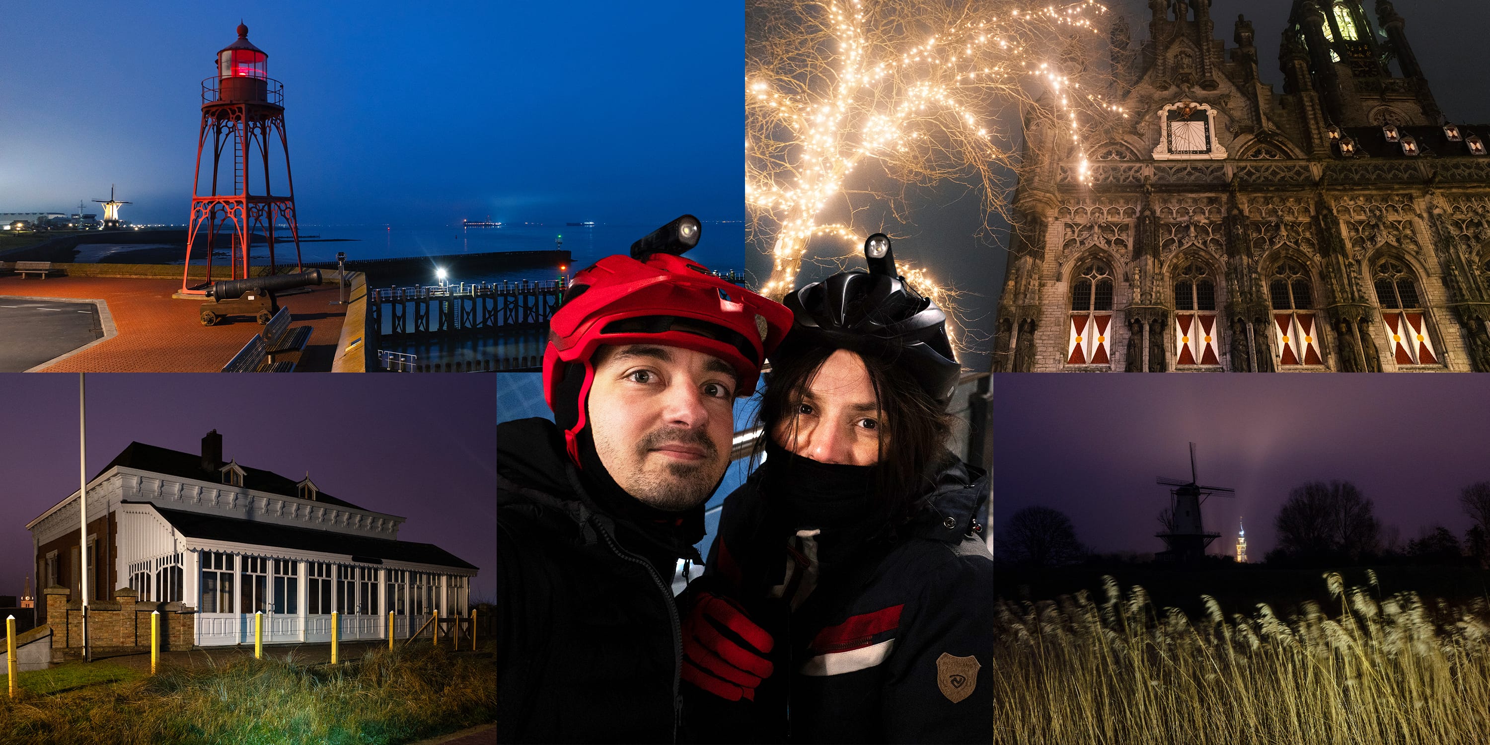
Then, we briefly stopped at the 15th-century town hall, a stunning example of Late Gothic. What was interesting is that locals were strolling in the very center, but just three minutes down a side street, it was utterly deserted.

It took us a couple of attempts to find the entrance to the Kuiperspoort, a cobblestone alleyway lined with historic warehouses of the coopers’ guild and small houses dating back to the 1600s. We stepped through the small gateway and it felt like a secret escape from the modern city. Because it was spared from the German 1940 bombardment that destroyed much of the city center, it remained one of the few places to experience the original scale of Middelburg.

Middelburg’s charm held us, but it was only the start of the ride. We eventually pulled away, cycling past the elegant, whitewashed windmill “De Hoop” (meaning “The Hope”). It stood motionless on the bank of the former water moat, its silhouette perfectly mirrored.

Our route led us toward the port of Vlissingen, connected to Middelburg by a perfectly straight canal. These seven kilometers were the most relaxing stretch — just a flat, effortless path following the water’s edge.

Vlissingen first emerged around the 13th century as a ferry stop for travelers moving between Middelburg and Flanders. Today, the city still plays a similar role, connecting the peninsular heart of Zeeland to the province’s southern reach — Zeelandic Flanders — and the Flemish region of Belgium beyond.

Most of Vlissingen looked like many other Dutch towns: cute brick houses, narrow streets, and colorful window shutters. But a truly unique spot was the ensemble of four Belgian pilots’ villas. These exquisite Art Nouveau houses were commissioned in 1910 by maritime pilots residing in the city. Art Nouveau is a rarity in Zeeland, and these villas are peculiar examples of the style. Each villa carries a name of the pilots’ children: Louise, Maria, Blanche, and Yvonne.

Note their asymmetrical facades and turquoise glazed bricks. And these bold red patterns? To me, they almost resembled hieroglyphs on ancient Egyptian tombs.

Despite having ridden just a short distance, we felt it was the perfect time for a tea break to stay warm in the chilly weather, especially as we approached the seashore. While I was busy taking photos of the villas, Oksanka popped into a nearby Polish grocery store and found our favorite Ukrainian “bamboo” cookie sticks—a taste of childhood!

As darkness fell and the “blue hour” set in, we went to the pier through the 16th-century Emperor’s Bastion, the only intact historical gate in the town. It dates back to when the Netherlands was under Spanish imperial rule, hence the name. While I initially thought Vlissingen was much like any other Dutch city, it was here on the shore that the city’s maritime soul finally revealed itself.

Then we went to the top of the bastion. It was adorned by a functioning modern replica of the 1891 red lighthouse. And I should say it was just the first of several unique lighthouses we would encounter that day — but probably the most adorable one.

The waves below lapped lazily against the sand and stones; everything felt remarkably peaceful. It was as if even the seagulls — who never stop shouting — had taken a day off.

Our route took us northwest along the sea toward the tip of the peninsula. But before leaving Vlissingen behind, we stopped by the Prison Tower, the remaining half of a medieval city gate that once consisted of two towers with a passage in between. The tower closer to the sea still stands today, and its name reflects its later use after the gate lost its defensive role as the town expanded.

While I hadn’t known about the tower before the trip, the next stop was definitely on my must-see list. It’s a treat for architecture nerds — the post-war Modernist Maritime Academy building (1950–1953). Though it appeared to be undergoing renovation, I could still capture a shot of its signature turret and porthole windows.

Then, we plunged into the darkness of the wilderness. I love those moments when the city’s illumination fades away, leaving nothing but the oval of light on the path and the wandering shadows cast on the trees by our helmet lamps.

Last year, I bought helmet mounts for our bike lights — just two simple plastic pieces secured with zip ties. But they allowed Oksanka and me to and me ride through complete darkness in the dunes and forests, occasionally spotting deer, horses, rabbits, and Scottish cows. Now, I can’t imagine going on an adventure without them.

We spotted numerous lights at sea — ships, windmills, and perhaps even some oil and gas rigs.

As we continued northwest, we entered a small forest and found a chain of “dragon’s teeth” — silent remnants of World War II fortifications designed to block tank movement. Our bike path cut through three lines of these barriers, and it was kinda symbolic that a peaceful road now passes freely through what was once built to halt war machines.

As I mentioned earlier, most of Zeeland lies below sea level, protected from flooding by a network of dams and dikes. At one point, the road veered inland, and we saw the steep dike stretching along the coast like a protective wall.

Soon, we arrived in Westkapelle, a village at the very tip of the peninsula. I recognized it immediately by the massive brick lighthouse, nicknamed the “High Light,” which I had read about before. It unusually stands in the middle of the village rather than on the shore. The reason is simple: it used to be a 15th-century Late Gothic church tower, repurposed as a lighthouse in 1818.

We stopped to take a closer look at the “High Light.” While it hasn’t always been a lighthouse, if we consider just its brick body, it can be regarded as the oldest lighthouse in the Netherlands.

We headed toward the beach and came across an American “Sherman” tank. This World War II memorial symbolizes Westkapelle’s liberation during the Battle of the Scheldt River in 1944. There was also a small museum nearby with a landing craft from those times exhibited outdoors.

Then, I noticed something unusual on a pole — it looked like an artwork from some street exhibition. Still wondering what it was.

And here’s another lighthouse! I told you there would be several along the route. This compact cast-iron red tower from 1875–1876 is called the “North Head” and stands just a few meters from the water. It was already dark, and since the nearby villages didn’t produce much light pollution, everything behind it appeared pitch black.

After visiting Westkapelle, we headed to Domburg. I had marked a couple of interesting buildings there, both designed by Dutch architect Johannes van Nieukerken.

The first place was Villa Carmen Sylva (1885), a unique example of a summer house in an eclectic style with Mediterranean vibes. The villa had two floors, with an upper level directly extending onto the dike and a large wooden veranda overlooking the beach. I wouldn’t mind living in such a villa in my old age.

On the inland-facing side, the villa looked almost ordinary, until I shone my lamp on it. Its color and texture felt foreign against the row of typical Dutch houses nearby. Since the building appeared empty, I let my lamp linger on the facade, pulling the fine details out of the dark without the worry of disturbing anyone.

And here’s van Nieukerken’s second creation in Domburg — a coffee- and bathhouse (1889). This building has had a complicated history, with periods of thriving and decline. Currently, its hall is used as a restaurant, and the remaining area is divided into several private apartments.

That was it for Domburg. We also took the opportunity to have some tea from our thermos with a couple of cereal and chocolate bars and enjoy the sea view from the elevated boulevard.

Our route took us east, and we had a much longer distance to cover before reaching the next site I had planned to visit. There may have been interesting places along the way, but we couldn’t spot them in the dim light. Plus, the sky was foggy—no stars or moon in sight.

And finally, we arrived at our next stop. Ta-da! Below is a photo of the place. Can you guess what it is?

The storm surge barrier was built across the Eastern Scheldt River between 1976 and 1986 to protect the country from sea flooding. Stretching nine kilometers, it is the largest structure of its kind in the Netherlands! Its construction was driven by the catastrophic flood on a January night in 1953, which claimed over 1800 lives and destroyed thousands of homes and farms, with most of the casualties in Zeeland.
The government initially proposed building a dam to cut off the river estuary from the sea completely. However, ecologists and fishermen opposed this plan, as it would have turned the estuary into a freshwater lake, destroying the entire ecosystem. As a result, the barrier was designed to allow water flow most of the time, only closing during storms.

Now, we were riding to Veere, the last town to visit before returning to Middelburg — just enough time to complete our plan and catch the last train. We were getting pretty tired and had run out of tea to keep warm in this insane humidity. I turned on the music on the portable speaker, and the ride felt much less monotonous.

We approached Veere from the north, where a powerful beam of light stretched across the moat. And guess who greeted us there? A cow! Or, to be precise, the “Cow” corn mill (“De Koe” in Dutch), perched atop a former rampart. Its silhouette was incredibly sharp, backlit from somewhere in the town center.

A few minutes later, we realized the source of the glow — the medieval town hall (1474–1477). It seemed oversized for such a compact settlement, but I suppose Veere played a more significant role as a port in earlier centuries, when whalers departed from here to hunt in the waters around Greenland. Yet, even more striking than the building itself was its illumination, which cast a pointed shadow onto the foggy sky.

We cycled toward the harbor and came across the old fortifications that once guarded the entrance against enemy ships. The burly 15th-century Campveerse Tower on the corner was impossible to miss. It’s said to house one of the oldest inns in the Netherlands. A place for travelers has existed within these walls since the 1500s, evolving into a lodging and coffee house, and eventually a restaurant.

I was in a state of near-gambling thrill; my mind was still craving more, even as my body longed for a soft pillow. The ride back to Middelburg was a quiet blank — just a few kilometers of road and no distractions.

We happened to pass the same spot where I’d taken that foggy, black-and-white photo of the Abbey Tower earlier, and I couldn’t leave without stopping for one more shot. This time, I captured it in color: the white, yellow, and blue illumination was all on, spilling an eerie pinkish glow into the misty sky.

Despite the unplanned stops for photos, we arrived with less than ten minutes to spare. It was nerve-wracking to think how easily we could have missed it and been stranded, but it meant we didn’t have to wait in the cold — especially since the station’s waiting room was closed for renovation.

On the train, Oksanka reached into her backpack and pulled out a pack of Ukrainian sour cream and onion chips — our favorite. She had bought them, along with the “bamboo” cookie sticks, at the Polish grocery store in Vlissingen. As we munched on the chips to stay awake, we swapped our damp socks for dry ones and warmed our hands and feet on the heater beneath the seat.

Leave a Reply